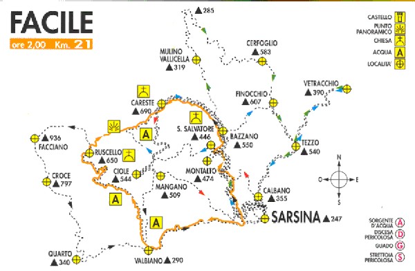
| EASY |
 The
route runs along the old Umbro-Casentinese national road for about 4 km,
and after the Marianna bridge, in Valbiano, it takes the roadway on the
right, which immediately starts climbing the valley of the Ruscello
Torrent.
The first stretch of road extends in the pleasant gorge and, after the
Fonte Macchie source, 3,5 km after, the horizon widens out: on the
other side of the bridge that crosses the stream, we can see beautiful and
sometimens magnificent landscapes, expecially at 750m above sea level,
where our gaze can sweep over the whole Appennines chain, with the
Fumaiolo Mountain (1300 m above sea level), the Carpegna Mountain (1415m)
the Aquilone Mountain (900m).
The downhill road, which passes by old abandoned cottages and parish
churches in ruins, leads, after 9 km, to the starting point.
Go
back to the "Mountain Bike" index
|
| MEDIUM |
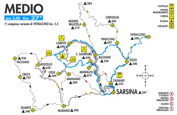 Leaving
from via Don Sturzo, in the upper part of Sarsina, follow the route
towards the "Marmitte dei Giganti".
When you reach the mule track in Careste, go along it until the
cross-roads to Montalto (474m). Here, turn left and go straight on until
you reach the ruins of the Abbey of san salvatore in Summano.
Following this route, the dirt route gets narrower and it rapidly leads to
the Mulinello ditch. After the ford, the route gets to the saiano ruin
(450m), then to the stone ruin (rudere dei sassi) (450m) and finally to
the crossing with the dirt road on the right which leads to Pian di Meglio
(668m).
After the bar at the end of the road you find yourself again, on the right,
in the upper stretch of the mule track of Careste (712m above sea level),
and you have to go down it for about 4 km, until the cross-roads near
Bazzano (550m).
Now turn left and go up to the top of the Finocchio Mountain (643m) and
when you reach the provincial road 128, turn right towards Tezzo.
Here you can choose, on the left, the variant of the itinerary which leads
to Vetracchio (390m), a charming place in a rural world which reminds of a
past age.
Once you have gone back to Tezzo, the route towards Sarsina is a
continuous descent.
Go back to
the "Mountain Bike" index
|
| MEDIUM |
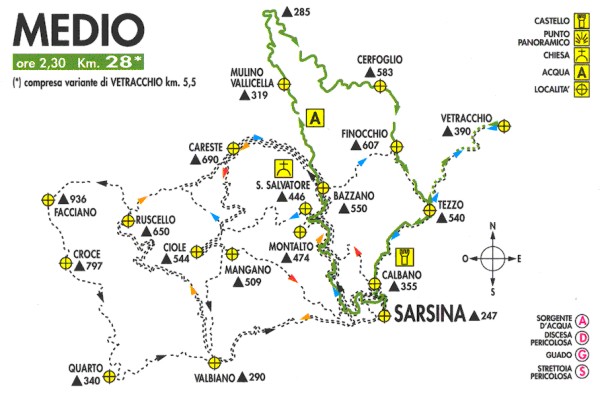 You
have to go down the mule track in Careste for about 5 km, until you are
over Bazzano (550m).
Shortly before reaching a little stone house on the left of the road, turn
right in path that, beyond a bar, starts descending along the slope of the
Guscella Mountain (559m).
once you have gone over the ruins of Cà Guscella, follow the steep
descent up to Rio Cella (319m). After fording the ditch, the path climbs
the hill up to the Mulino Vallicella (353m), Here, the road widens out and
it easily leads to the provincial road 128 which, on the right, leads to
Sarsina.
Once you are beyond the Finocchio Mountain pass (607m), you have to
descend for about 2 km, until you reach Tezzo. On the left you find the
starting point of the variant of the itinerary which leads to Vetracchio
(390m), a charming place situated in a rural world which reminds of a past
age.
Once you are back to Tezzo, the route towards Sarsina is a continuous
descent.
Go back to
the "Mountain Bike" index
|
| DIFFICULT |
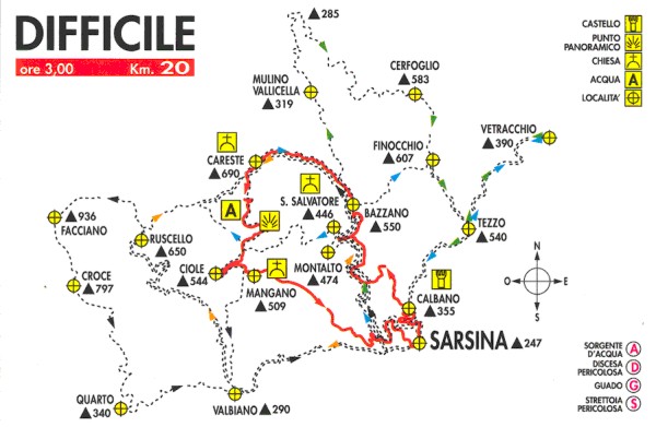 Once
you have taken the provincial road 128, in the direction of Ranchio, after
2 km you arrive in Calbano
(355 m.). After going over the ancient towers, take the dirt road on the
left. This road first runs along the new "Arena Plautina" and a
countryside with typical hill cultivations, then it rapidly runs down to
Rio della Crocetta. From this point, it re-ascends, with some difficulties,
up to the mule-track in Careste.
After 6 km you have to go over the parish church of Careste, 690 m above
sea level, and take, on the left, a spectacular technical route, all ups
and downs, which leads to the old little church of the Madonna del Mangano
(590m), passing through different kinds of landscape.
You then have to take the bare path on the left which leads to a dirt road
running to Tibbio and to the Casetta di Campagna.This road goes back, 1 km
after, to the mule-track in Careste.
After that, you have to take the ascent on the left and climb for about
200 m, then take the road on the right which leads to the Marmitte dei
Giganti".
Following this route, after 500 m you get to the upper part of Sarsina.
Go back to
the "Mountain Bike" index
|
| VERY
DIFFICULT DIFFICILE |
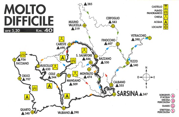 Starting
from the upper part of Sarsina, you enter the old mule-track which leads
to the"Marmitte dei Giganti".
Following this route, you reach the mule-track of Careste and, 7 km after,
you pass the parish (690m) with the same name.
Once you have taken the pathway on the left, you will confront technical
descents, fords, chestnut woods, maquis, until you reach the ruins of the
church of the "Madonna del Mangano" (509m).
Not far, on the right, through a breathtaking descent, you reach the
Ruscello ditch and run along it up to the church of Valbiano , after
pushing your MTB along 100 m of hard ascent.
You then have to turn right and take the cartroad of Careste. Once you
have passed the Ruscello parish in ruins (650m), after a few hundreds
metres, take a steep dirt road and the, on the right, a path which
will lead you on the top of the Monte di Facciano, (936m), the highest
point of the route. Among pastures and woods, along continuous ups and
downs, you arrive at the Bandiera Mountain (823m).
From here, run along panoramic descents, among beeches and pines woods up
to Quarto (340 m.) and its lake.
The route back passes along the Umbro-Casentinese national road, for 7 km
up to Sarsina.
Go back to
the "Mountain Bike" index |